60.2 F
Clarksville
Saturday, April 26, 2025
Home This map shows the path of the 2017 total solar eclipse, crossing from Oregon to South Carolina, and the 2024 total solar eclipse, crossing from Mexico into Texas, up to Maine, and exiting over Canada. This map shows the path of the 2017 total solar eclipse, crossing from Oregon to South Carolina, and the 2024 total solar eclipse, crossing from Mexico into Texas, up to Maine, and exiting over Canada.

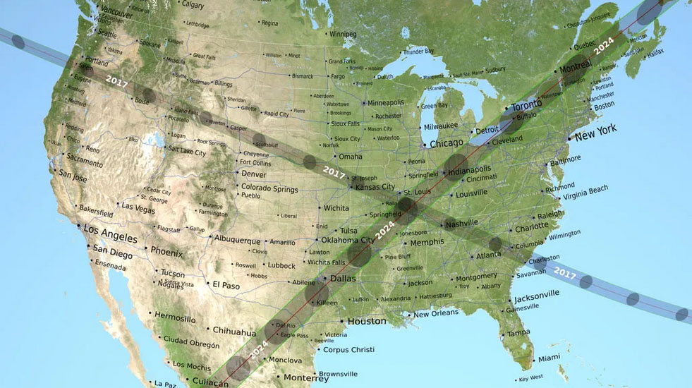
This map shows the path of the 2017 total solar eclipse, crossing from Oregon to South Carolina, and the 2024 total solar eclipse, crossing from Mexico into Texas, up to Maine, and exiting over Canada.

This map shows the path of the 2017 total solar eclipse, crossing from Oregon to South Carolina, and the 2024 total solar eclipse, crossing from Mexico into Texas, up to Maine, and exiting over Canada.

This map shows the path of the 2017 total solar eclipse, crossing from Oregon to South Carolina, and the 2024 total solar eclipse, crossing from Mexico into Texas, up to Maine, and exiting over Canada.

The total solar eclipse on August 21st, 2017, was photographed from Madras, Oregon. The black circle in the middle is the Moon. Surrounding it are white streams of light belonging to the Sun’s outer atmosphere, called the corona. (NASA/Aubrey Gemignani)
The third rocket launched on October 14th, 2023
Clarksville Online - Clarksville News, Sports, Events and Information