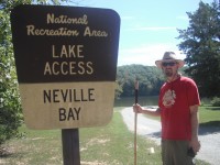
This is the second in a series of articles about my experiences and what I have learned about the Land Between the Lakes National Recreational Area. Neville Bay is located at 36*36’43.29 N by 87*54’55.08W, elevation 352 feet.
 One of our favorite bays to canoe and camp in LBL is Neville Bay. Neville Bay is located in the southern end of LBL in Stewart County, Tennessee. Although it has a permanent toilet (which we have always found to be clean), the lake access area does not have running water. Guidebooks rate the bay as a low use area. Our experience is that although fishing boats use the boat ramp daily, we are usually the only campers.
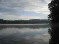
The bay is fed by Neville Creek, which runs through Crutcher Hollow. Running west to east, the bay meets the Cumberland River/Lake Barkley at a relatively narrow and shallow inlet (especially after Labor Day.) The bay is much shallower on the north side, where the camping area is, and would be great place for swimming – caution – wear water shoes. The bay’s south side is rocky, deep, and has a very steep shoreline. The seeming lack of water depth seems to discourage ski boats and jet skis. This is a fisherman’s bay, making it great to paddle around in, even if it is not as protected by the wind as much as some of the other bays.

 The bay is easily accessible by a good gravel road. I have no problem getting there in my loaded down little Mazda. The May floods took out a culvert on Road 214, and Neville Bay was only accessible by the slightly rugged Road 213, Crutcher Hollow Road. But now that road 214 is open Neville Bay is less than ten minutes off the Trace, the entrance to the area is on the right.
Camping here requires a Backcountry Camping permit. Permits are $20 for those over 18; under 18 do not need a permit. I think large groups must register with park staff. There are several picnic tables and fire rings located around the campground. We have two favorites camping sites at Neville Bay. The first is to the left of the boat ramp, facing east over the bay towards Lake Barkley. Having a tent tucked in behind trees on the shoreline, will keep your tent shaded in the morning sun – but you’ll sacrifice some privacy when the boats arrive at sunup. The other campsite we prefer is down the western portion of the shoreline under the far trees.
From this second site, we were hidden, and watched numerous herons and egrets fish every morning. One old Great Blue Heron always flew in noisily from the south side of the bay (“frahnk, franhkm, franhk!!), and  making a ruckus, the swooping down to chase the younger herons away. My wife snapped a good action shot, sitting 15 feet away. We canoed out over the mist the next morning, moored to a tree, and watched back across the bay, watching 10-12 herons and egrets spread about 20-40 yards apart on the opposite shore fishing. They walk very slowly, stop, wait, and then quickly shove their heads into the water, grabbing a fish with their long beaks. They didn’t seem to mind us being around, as long as we didn’t get to close.
 If a hike sounds like a good idea, a walk to secluded Nevil Cemetery is merely 3/4th’s of a mile away. Head back to 214, and go west towards the Trace. The cemetery is on the right, and well maintained. No camping is allowed in a cemetery. Right before you get to the cemetery road, at the right time of year, you’ll see purple grapes growing, a reminder of times past.
If a drive is more your speed, stay on 214, going past the access area. The 214 to 204  route has been noted as one of the areas most scenic drives. The route is very drivable, but for those with four wheel drive and a good adventurous attitude, there are several spur trails (less traveled off shoots) to explore. The 214/204 route passes numerous old homesteads, easily identified by the remaining steps, foundations, and concentrated spring flowers. Road 204 connects with the Trace at the Great Western Furnace.
Once while breaking camp, we were approached by a gentleman looking for his fox hounds. Turns out, he was 94 years old, born one hollow over (maybe Fox Hollow), owned the surrounding land before the TVA came in, and farmed the land that is now under Neville Bay. You may remember from my first article that I have family ties to LBL. Unfortunately, this nice man didn’t seem to know my family, but a great memory we made. Mr. Allen – I hope you found your fox hounds!
I have posted some of my wife’s pictures to Google Earth. See the link below. Educate yourselves about the rules at LBL…the information in this article will get outdated. If you have any specific questions, please email me. Hope to see you outdoors!
Resources
- Land Between the Lakes – http://lbl.org/index.html
- First article in the LBL Series – https://www.clarksvilleonline.com/2010/09/08/lbl-series-the-gift/
- More photos, uploaded to Google Earth – http://www.panoramio.com/user/4946426